The assessment of practical skills is a compulsory requirement for EDUQAS A Level Geology. In our packed 3-day course, students will complete a range of Specified Practical’s (SPs) and use practical techniques to develop their fieldwork and investigation skills.
Students will be able to meet the Common Practical Assessment Criteria (CPAC), for example, by completing risk assessments. Students will be required to “think geologically” about unfamiliar locations and use a variety of IT software and spatial systems to collect, analyse, and present data.
Example Timetable
Day 1
Arrive Midday
- Students will be greeted by staff, with a welcome talk followed by a brief tour of the centre and the local area.
- Outline of the course
- Allocation of walking boots/waterproofs, and geology field kits.
Afternoon
Introduction to the Geology of the Local Area
- Students will visit a local field site and immerse themselves into the local geology through observations and interpretations to build up their knowledge of the geological history of the area.
- SPs may include: SP5, SP8, SP10, SP14
Evening
Skills Workshop and Follow Up
- Workshops may include one or a combination of the following: Quantitative analysis (e.g. statistics) / Data Presentation / Geographical Information Systems (GIS) / Using secondary data sets.
Day 2
Morning & Afternoon
Investigating Crystalline and Orogenic Processes
- Students will investigate metamorphism around an igneous intrusion, identify minerals and record a geological map of the structures and orientations.
- SPs may include: SP3, SP4, SP8, SP10, SP12, SP13
OR
Investigating Geological Sequences
- Students will use the fieldwork; investigation skills and sampling strategies developed throughout the week to complete a mini-investigation and produce a graphic log of a geological exposure. Students will use their geological observations, structures and field sketches to interpret the geological history of the location.
- SPs may include: SP6, SP12, SP13, SP14, SP15
Evening
Skills Workshop and Follow Up
- Workshops may include one or a combination of the following: Quantitative analysis (e.g. statistics) / Data Presentation / Geographical Information Systems (GIS) / Using secondary data sets.
Day 3
Morning
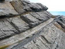
Sedimentary Processes
Students will identify sedimentary rocks and structures in the field and record orientation to interpret paleocurrent direction.
SPs may include: SP4, SP5
OR
Fossils in the field
Students will identify fossils and record observations and measurements in the field.
SPs may include: SP16, SP17
Depart at Midday
A final farewell from our staff as the students depart at midday
Please note: to ensure safe and quality learning experiences for students, the timetable may alter depending on weather conditions and local factors at centres.
How this course fulfills the specification
During a 3-day course it may be possible to complete the following:
SP4 Production of scaled annotated scientific drawings of rock samples from hand samples using a light microscope, or hand lens observation.
SP5 Production of full rock description of macro and micro features from hand specimens and unfamiliar field exposures of sedimentary rocks in order to interpret component composition, colour and textures, to identify rock types and to deduce their environment of deposition.
SP6 Construction of graphic logs using appropriate scale and symbol sets for unfamiliar geological sequences and exposures to record data relevant to an investigation.
SP8 Production of full rock description of macro and micro features from hand specimens and/or unfamiliar field exposures of igneous rocks in order to interpret component composition, colour and textures, to identify rock type and to deduce their cooling history.
SP10 Production of full rock description of macro and micro features from hand specimens and/or unfamiliar field exposures of metamorphic rocks in order to interpret component composition, colour and textures, to identify rock type and to deduce the temperature and pressure conditions of their formation.
SP12 Location of geological features onto a base map.
SP13 Identification of the location of geological features in the field using six figure grid references on maps.
SP14 Production of scaled, annotated field sketches at unfamiliar field exposures to record data relevant to an investigation.
SP15 Measurement of dip and strike elements: dip angle, dip and strike directions of planar surfaces, relevant to an investigation.
SP16 Application of classification systems using distinguishing characteristics to identify unknown fossils.
SP17 Production of scaled, annotated scientific drawings of fossils, using a light microscope, or hand lens observation.
Added value of this course
Develop skills
- Communication | Resilience | Independent thinking | Leadership
- Numeracy | Literacy | Investigative skills | Observation
Enhance Knowledge
- Ask questions.
- Apply knowledge in the real world and make links.
- Make sense of new places and understand our place and role within this.
Enjoy
- Have fun | Make friendships | Connect with nature
Why Choose Field Studies Council?
-

Expert tuition by fully trained staff
-

Stunning locations across the UK
-

Outstanding curriculum knowledge
-

Rigorous health and safety procedures
-

Support before and after your visit
-

Free places for visiting staff