All glacial landforms in the British Isles are fossil landforms.
Although the exact number of glacial and interglacial periods in the British Isles is still a matter of scientific debate, the relict landforms which can most easily be studied in the field were heavily modified by glacial erosion and deposition in the Devensian period, at its maximum extent 18,000 years before present. At this time, sea level was 100m lower than today, and land bridges linked Britain to France and Ireland.
“A house burnt down by fire did not tell its story more plainly than did this valley. If it had still been filled by a glacier, the phenomena would have been less distinct than they now are.”
Charles Darwin 1842, describing the landscape at Cwm Idwal
‘A house burnt down by fire did not tell its story more plainly than did this valley. If it had still been filled by a glacier, the phenomena would have been less distinct than they now are.’ – Charles Darwin 1842, describing the landscape at Cwm Idwal
What questions do geographers ask?
You can ask geographical questions about anywhere in upland landscapes. Photographs, map views and Google Earth views can help you. Here are some examples.
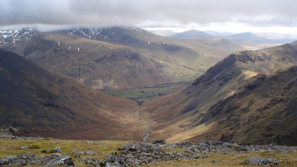
- What was the role of ice in the formation of this valley?
- Why are the hills on the left of the photo less craggy than the hills on the right?
- How has this location changed since deglaciation?
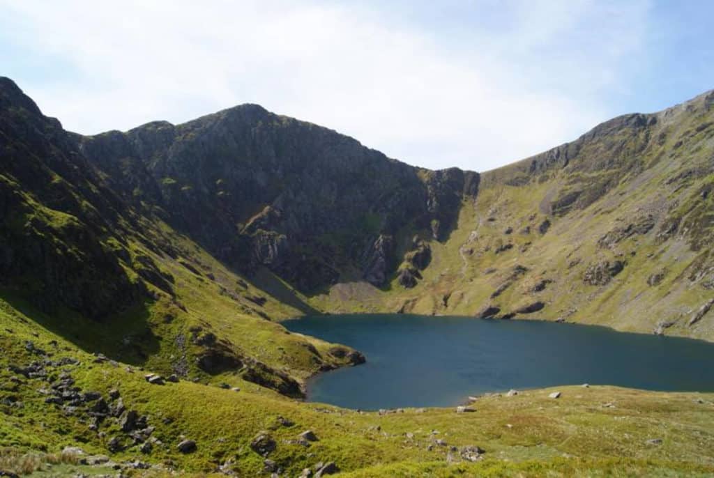
- What volume of ice did this corrie once hold?
- How much of what you can see is a relict landform and how much is still active?
- Why is the lake not a perfect circle?
- Is there evidence of recent frost shattering at the top of the slope?
- How and why does the scree vary in size and shape up and down and across the slope?
- Why isn’t the whole hillside covered in scree?
What could you investigate by fieldwork?
Here are some examples. Each research question has been split into 2 or 3 sub-questions.
| Research questions | Sub questions |
|---|---|
| Why is there an uneven distribution of erosional landforms in the upland landscape at x? | Where are erosional landforms (like corries, glacial troughs and hanging valleys) in the landscape at x? How was the rate of glacial erosion affected by rock type, structure, aspect and altitude? What postglacial changes have occurred? |
| How and why do corries vary in upland area x? | How do the corries vary in size, shape, backwall steepness, altitude and aspect? Is there a link between corrie size and some other factor (like aspect)? What postglacial changes have occurred? |
| Which periglacial landforms at x are still active? | Where are periglacial landforms (like stone polygons, head deposits, tors, scree slopes) in the landscape at x? Is there any evidence that scree slopes and/or stone polygons are actively forming? |
Specialised geographical concepts
A good way to demonstrate challenge in your choice of research question and/or sub questions is to consider one or more of the specialised geographical concepts. Here are a few suggestions:
| Specialised concept | Research question or sub question |
|---|---|
| Causality | How important is glacial erosion to the formation of the landscape at x? |
| Causality | What is the relationship between the rate of erosion and the resistance of the rocks? |
| Causality | An assessment of the relative significance of preglacial processes, valley glaciers, ice sheets and postglacial changes in forming upland landscape x |
| System | Using field evidenct to reconstruct the glacial budget for corrie x, or glacial trough y |
| Equilibrium | Are corries in upland area x an equilibrium form? |
Choosing a fieldwork location
For a survey of an upland glacial landscape, you could either concentrate on a single landform (such as one corrie or one glacial trough) or study up to 1-3 square kilometres of country. Alternatively contrast a number of landforms in a particular area (such as corries) using a mixture of field visits to a sample plus map evidence for a greater number.
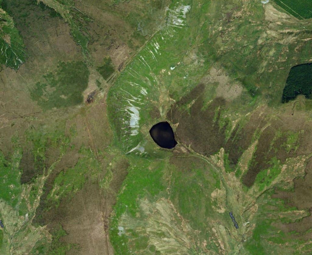
A possible fieldwork location: Llyn Lluncaws and Moel Sych in the Berwyn Mountains, North Wales. Approximately 2 square kilometres shown. Open access land throughout. Safe access points to the shoreline at several points around the edge. What glacial landfoms are present? How and why did the rate of glacial erosion vary? What postglacial changes have occurred?

Secondary and Further Education Courses
Set your students up for success with our secondary school trips and courses. Offering excellent first hand experiences for your students, all linked to the curriculum.
Group Leader and Teacher Training
Centre-based and digital courses for teachers