Quantitative Methods
Sampling
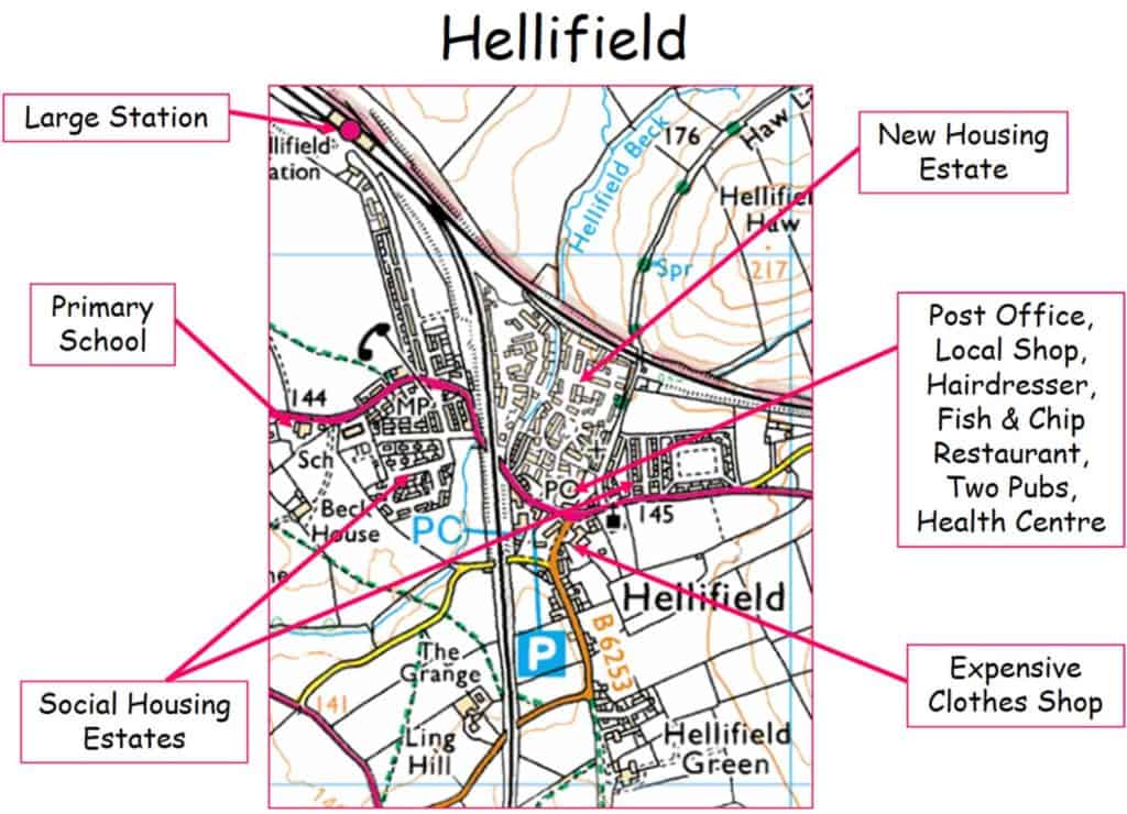
Questions focussing on spatial changes consider comparisons between different parts of the settlement in terms of services, housing, crime and accessibility. In Hellifield, that might involve comparing the new housing estates with the areas of social housing.
Temporal changes might mean investigating how services, population and housing and services have changed over time. In more dormitory settlements – where residents commute to work during the day – it may be possible to identify changes between different times of the week or days of the week.
Measuring flows of people within a rural settlement
Pedestrian survey to consider the type of person, where they are, what they are doing within different parts of the rural settlement. This could be conducted at differing times of the day or year. It is useful to have some secondary data for comparison or perhaps from webcam captures if available. If there are old photographs of the village, counting the people in that might provide some information to compare changes over time.
Pedestrian flow count and observation
In each location for a 2-minute period tally the pedestrian type and note down any identifying characteristics.
| Participant Type | Tally | Characteristics |
|---|---|---|
| Family Groups | ||
| Child (under 12) | ||
| Young Teenagers (12-14) | ||
| Older Teenagers (15-18) | ||
| Retired | ||
| Other |
Traffic survey: This might include determining the noise level, measuring the speed of the traffic, as well as count different types of transport and the numbers of people using it. This count could also be conducted at differing times of the day.
| Traffic count | Tally | Total | % of all traffic |
|---|---|---|---|
| Lorries | |||
| Coaches/Buses | |||
| Vans | |||
| Minibuses | |||
| Agricultural vehicles | |||
| Cars | |||
| Motorbikes |
Recording the quality of the environment.
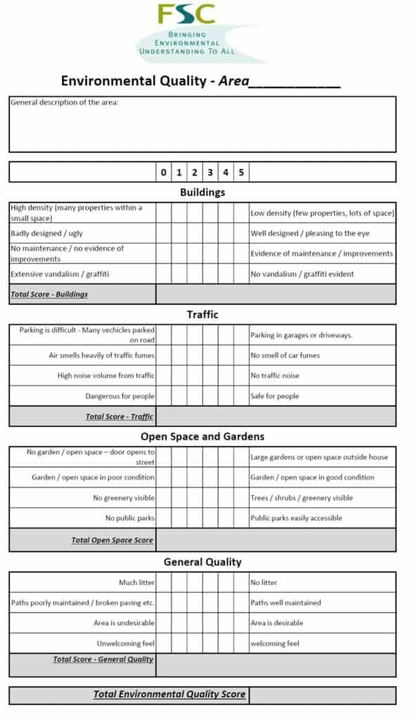
An environmental quality survey uses an observer’s judgements to assess environmental quality against a range of indicators. Often they work on a sliding scale of quality (like 1 to 5) to represent less good to good. Alternatively you can use a Bi-polar scale (like -5 to +5) to indicate a negative assessment through to a positive assessment, with 0 representing neither good or bad.
As it is based on personal judgements the data collected using environmental quality surveys is subjective. Benchmarking the scoring between different observers will help reduce this subjectivity.
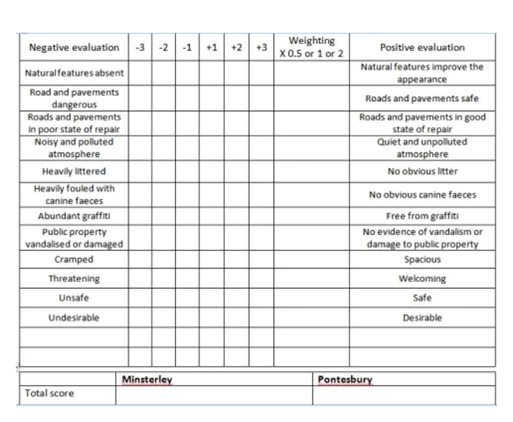
Sampling for environmental quality surveys within a study like this could occur in several different ways:
- Transect – along the transects used for recording spatial changes in land use you could also complete an environmental quality survey every 200m, either a summary of the last 200m, or based on the immediate area.
- An overall judgement of an area – the shopping area is divided into zones: walk around the whole of a zone and then complete the survey as a summary of the whole of that zone.
- Locations chosen before fieldwork – before leaving for the fieldwork a number of survey points are chosen (selected using a random, systematic or stratified sample).
- Locations chosen during fieldwork – select representative locations to carry out the survey – these could be the worst place in that area, the best place in that area and an average place in that area.
Recording site location
The easiest way to accurately record the locations of your sampling sites is to use a GPS – there are many different Smartphone apps that will allow you to do this. If you want to use GIS to locate your sites on a map or to display your data, you need to record your location as latitude and longitude.
Qualitative Methods
In addition to Environmental Quality surveys as described above which quantify the quality of the rural environment we can use a range of methods to collect information about environmental quality in a qualitative way.
Questionnaires
Questionnaires or informal chats with the public might ask the following
- ”How long have you lived here?”
- “What do you like/not like about the village?”
- “How has the village changed in the time you have lived here?”
Annotated photographs and field sketches
Use annotated photos or field sketches to make a judgement about the quality of the environment. You could photograph at whole street scenes, or focus on small details such as a pile of rubbish. Alternatively construct a checklist of things to look out for, such as buildings, road and paving, litter, dereliction, street furniture, graffiti and fly posting.
Re-photography
Re-photography means that you look for old photographs and try to take a photograph of how exactly the same place looks today. Compare and contrast the two scenes. You could us the same technique to compare how a place changes over different days of the week or at different times of day.
Epitome words
A simple way of gauging perceptions of a place is to use epitome words. Think of a single word that sums up that area. These can then be put into a word cloud (e.g. wordle) and used to compare different areas.

Secondary and Further Education Courses
Set your students up for success with our secondary school trips and courses. Offering excellent first hand experiences for your students, all linked to the curriculum.
Group Leader and Teacher Training
Centre-based and digital courses for teachers