Two thirds of the world’s population live within a few kilometres of the coast. But the coastline is a vulnerable place; at risk from storms, erosion, deposition and sea-level rise. Given its importance we need to carefully consider how we manage the coastline to ensure that we can make use of its resources while still preserving its natural beauty and processes.
More than 250 million visits are made to the UK’s coast per year… with seaside tourism valued at £17 billion.”
UK National Ecosystem Assessment 2014
Coastal management can be put into the four categories:
| Do nothing | Allow natural processes to take over. This may lead to areas of land being lost to the sea |
| Hold the line | Keep the coastline at its present position. This may require a range of engineering solutions |
| Managed retreat | Allow the coastline to retreat but in a staged and managed way |
| Advance the line | Defences are built out at sea |
By recreating a naturally functioning shoreline we free ourselves from the ‘sea defence cycle’ of construct, fail and reconstruct. This must surely be more cost effective in the long run and more desirable in terms of maintaining the coast’s natural beauty. It does mean making some tough choices, but we can’t just store up the problems for future generations to deal with.
The National Trust
What questions do geographers ask?
You can ask geographical questions about anywhere on the coast. Photographs, map views and Google Earth views can help you. Here are some examples.
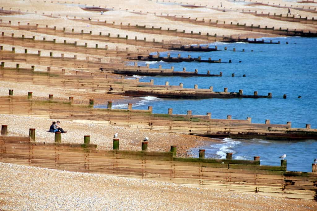
- How do these hard defences affect the beach sediment system?
- What historical evidence is there for the impact of these hard defences?
- Are these hard defences sustainable?
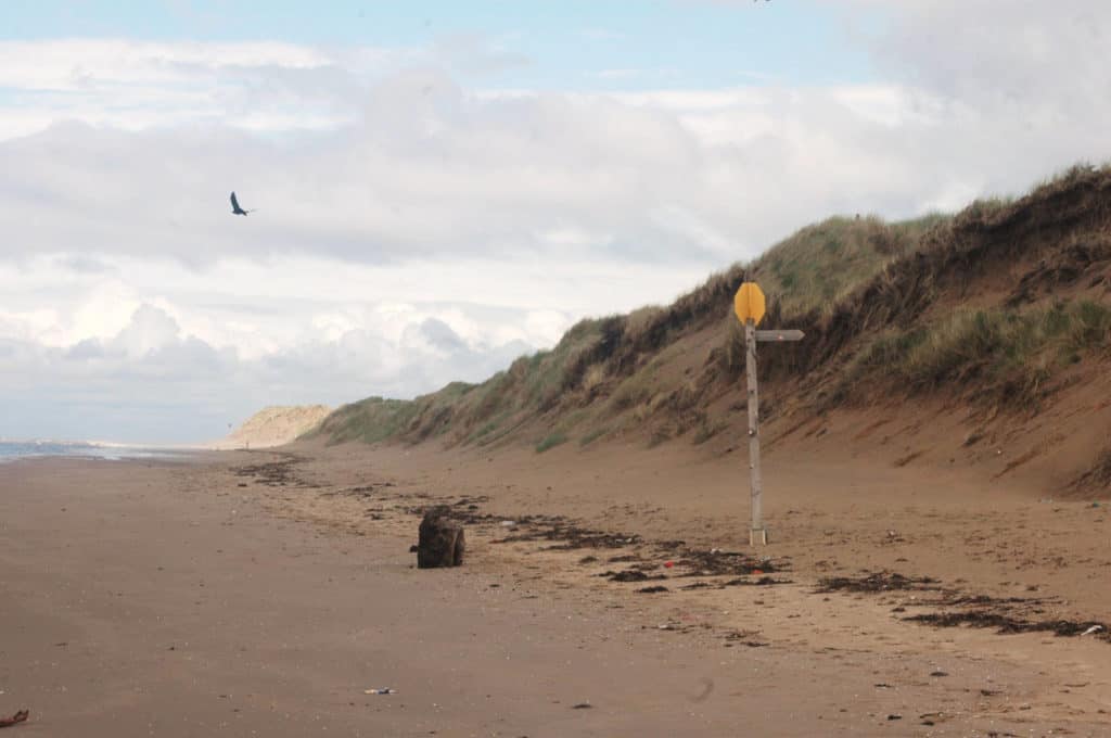
- What happens to the sediment which has been eroded from the sand dunes?
- When did the sediment balance change from accretion to erosion?
- Should anything be done about erosion of the sand dunes?
News reports and recent research articles provide interesting themes around which you can ask geographical questions. Here are a few examples.
Explore real-time data (including wave direction and height) and a gallery of photographs from across the coast of England and Wales at the Channel Coast Observatory http://www.channelcoast.org/data_management/real_time_data/charts/
What’s in your backyard? (Environment Agency) provides maps of the coastal erosion management policy in England. Here is an example.

The Steart Coastal Management Project in Somerset, completed in September 2014, is one of the largest managed realignment projects in the UK. But there have been critics, such as the local MP, who has called the project “Disney for ducks“
What could you investigate by fieldwork?
Here are some examples. Each research question has been split into 2 or 3 sub-questions.
| Research questions | Sub questions |
|---|---|
| What is the impact of the coastal defences at x? | Where are the hard defences at x? What is the impact on the hard defences on longshore drift and the rate of deposition? Is there any historical evidence for the difference that the coastal defences have made? |
| Is coastal squeeze happening at x? | What is the land use along the coast at x? How vulnerable are different places along the coast at x to coastal flooding and rising sea-levels? Is there any historical evidence for changing land use along the coast at x? |
| How successful are the coastal management strategies used at x? | What coastal management strategies are used at x? What is the impact of coastal management on longshore drift and the rate of deposition? Can the coastal management strategies at x be compared with strategies along a contrasting stretch of coast? |
Specialised geographical concepts
A good way to demonstrate challenge in your choice of research question and/or sub questions is to consider one or more of the specialised geographical concepts. Here are a few suggestions:
| Specialised concept | Research question or sub question |
| Causality | How has the sea wall at x altered the rates of erosion and deposition? |
| System | How do groynes at x affect the sediment budget along the coast? |
| Risk | What factors put the coast at x at risk of coastal flooding? |
| Resilience | How resilient is the coast at settlement x to changing weather patterns associated with climate change? |
Choosing a fieldwork location
Choose a stretch of coast with some variation. The Environment Agency “What’s In Your Backyard” website shows how the risk of coastal flooding varies across the country.
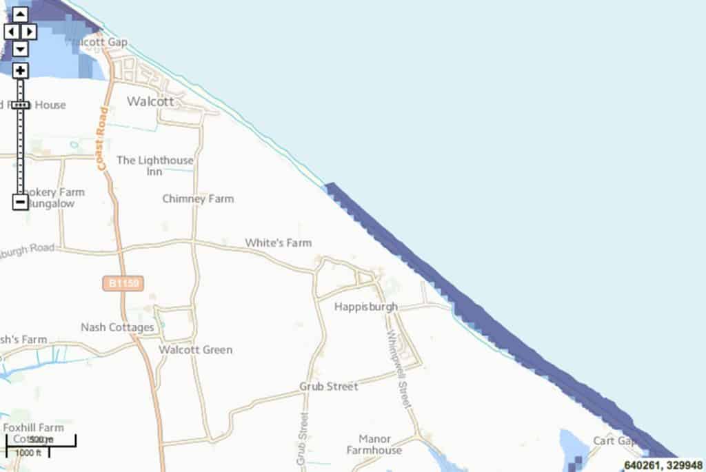
A possible fieldwork location: Happisburgh in Norfolk. Length of coastline shown is approx 3km. Why is there a high risk of flooding at Happisburgh (purple shading) but little risk of flooding at Walcott? What coastal management strategies are used? How vulnerable is human activity to coastal flooding?

Secondary and Further Education Courses
Set your students up for success with our secondary school trips and courses. Offering excellent first hand experiences for your students, all linked to the curriculum.
Group Leader and Teacher Training
Centre-based and digital courses for teachers